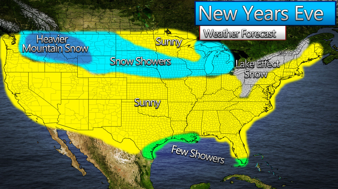
Good afternoon! Our website is back! Now let's head to the weather. We are looking at a weak clipper system to hit the Northern US by tomorrow evening, and make it's way to the East Coast by Saturday evening. Expect widespread 1-3 inch totals, although portions of the Upper Ohio Valley, as well as Middle Appalachians, have a chance for up to 6 inches of snow. Here is my forecast for this system!. Stay tuned and stay warm! -Mark 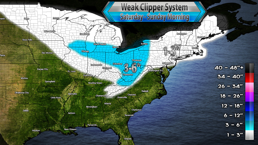
Good evening everybody, Lots of things to talk about, as we are heading into a pretty interesting pattern, good for a big Northeast snowstorm. First, let's talk about the near-range. Currently, we have a soaking rainstorm going in the Southeast, which is gonna translate into the Mid-Atlantic and Lower New England tomorrow. However, Upper New England, especially elevated areas of Vermont and New Hampshire, will be seeing a snowstorm. Here is my rainfall forecast for tonight through Monday morning. 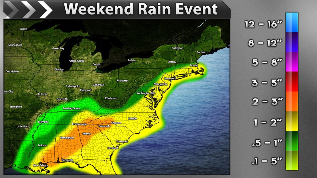
Although the heaviest totals will be in Alabama and Georgia, a soaking rain with nearly as much as 2 inches totally will spread through the Eastern seaboard. Now here is my snowfall forecast for tonight through Monday morning. 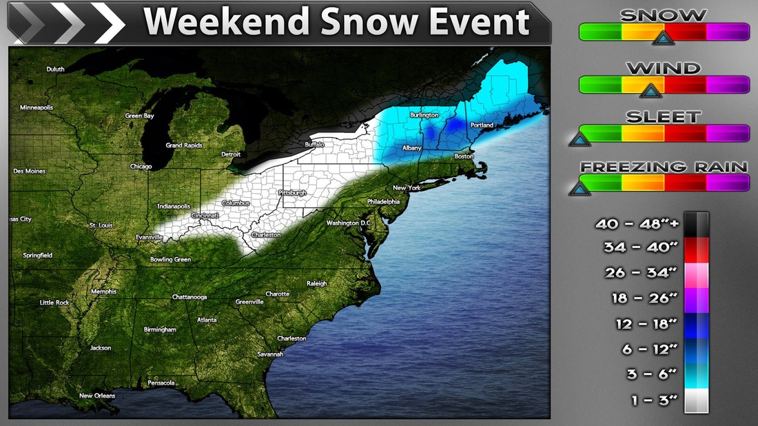
Highest snowfall totals in the Black Mountains of NH and around the mountain of Killington in VT. However, widespread 6-12 inches will still be possible in much of VT, NH, ME, and even portions of NY. We cannot rule out an inch of snow in the Ohio Valley and the mountains of West Virginia too, although it is not very likely. Now about the long-range, the pattern looks to be very good for a snowstorm, especially when models show it! First of all, let's take a look at the GFS's heights forecast for Friday morning. It shows an Aleutian Block, a week Greenland Block, and a pretty big system in the east. All looks perfect for snow! 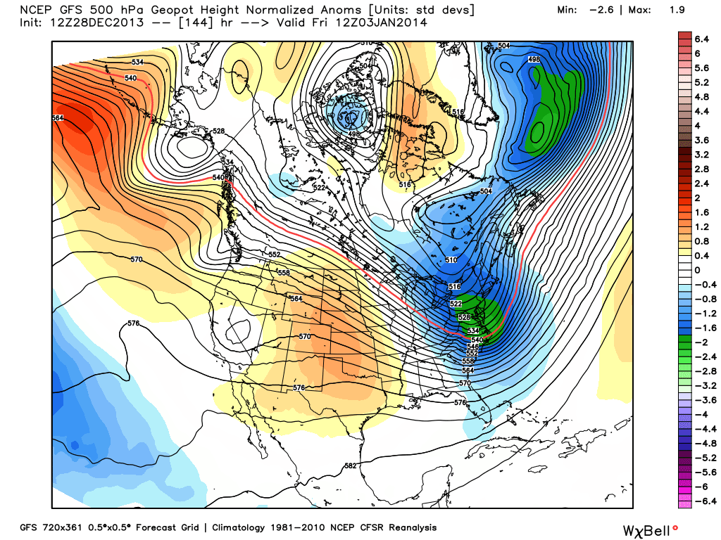
Now, let's take a look at a few runs of the GFS for late next week in terms of Precipitation Type. On Thursday Night, we have a large swatch of Moderate Snow across the Northeast and Mid-Atlantic. 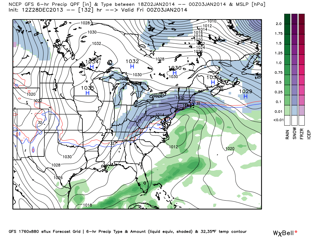
Now here is how it looks like on Friday Morning. 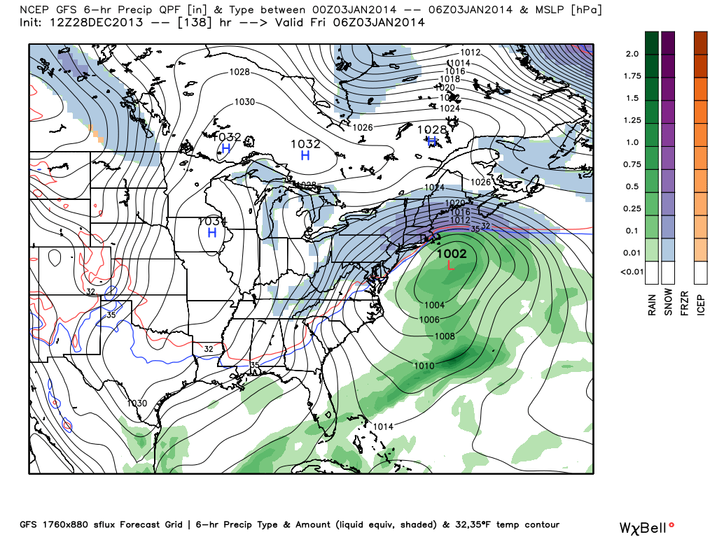
Now here is what the European Model looks like on Thursday evening. 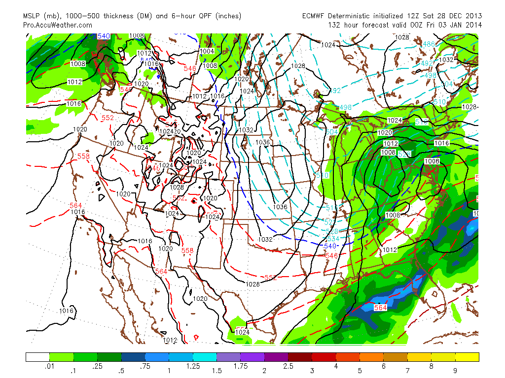
European Model on Friday morning. 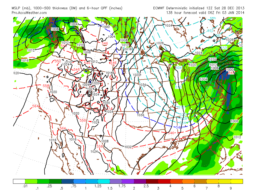
Finally, here is what the CMC shows on Friday Morning. 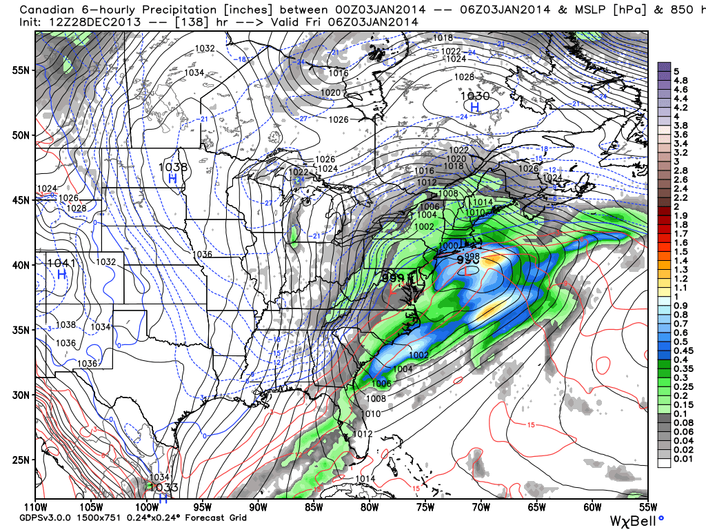
All three models agree on a good sized snow event for the Northeast, so here is my preliminary take on this.
Due to the blocking and teleconnections going perfectly, I would currently think that a coastal storm or even a nor'easter will be possible. Although I am not sure about snowfall totals just yet, I am pretty confident that we will see some sort of snow accumulation from TN/NC to Maine. All the models above are not forecasts, just model outputs that can always turn out wrong. However with the pattern fitting in, I would grant a rather high chance of this happening, although again, it is still far out. thanks for reading, and stay tuned for updates on the possibility of this winter storm! -Mark As we head into Saturday, a severe weather outbreak unrolls across the south. We have a couple watches already in effect, and here is a link to the latest SPC Day 1 Outlook. http://www.spc.noaa.gov/products/outlook/day1otlk_1630.gif Below is also my forecast map for today. -Mark 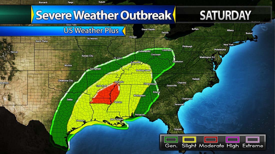
Below are the requested hometown winter forecasts. Hometowns are sorted alphabetically.
A None B Bridgewater, VA - Lisa McClanahan Miller Expect a pretty normal winter. Lots of mixed events, as well as some heavy rain or heavy snow events. Appalachian Runners and Clippers will be the main storm tracks impacting the area. C Cleveland, GA - Kelly Conard & Becky Whitlock Winters are pretty snowless in this area. Expect a lot of rain this winter, and numerous mixed.freezing rain events. There could be a few minor snow events as well. Main storm track will be the Appalachian Runners that will impact the area. D DuBois, PA - Bert Toss Expect above average snowfall in this area. Lots of lake effect snows and mix to snow events. Heavy rain events will be possible too. Main storm tracks will be numerous Clippers, Appalachian Runners, and Panhandle Cutters. E East Machias, ME - Susan Foss Expect an average winter with lots of snow and mixed events. On rare occasions, rain storms will be possible too. The main storm tracks will purely be Appalachian Runners and Clippers that choose to go up the coast. F Frederick, MD - Sherri Smith Luttrell Expect a winter with numerous rain events, as well as a lot of mixed events, and many light snow events. Heavy snow events would be possible too once in a while. The main storm tracks will be Appalachian Runners and Clippers. G Gaffney, SC - Tammy Horne Winters are pretty snowless in this area. Expect a lot of rain storms, a few mixed events, and some light snow to end on rare occasions. Main storm track will be Appalachian Runners. If you get really lucky, a strong Nor'easter would be your best bet for some higher snowfall totals. H None. I None. J None. K Kingsport, TN - George Carter Expect a slightly snowier than normal winter. Most systems will bring mixed precipitation, although depending on the track, it could be both pure rain or pure snow events. In addition, there will be pure light snow events as well. The main storm tracks will be Appalachian Runners and clippers, if they will go south enough. L Lancaster, PA - Brian E Thomas Expect a rainy winter. There will be many rainstorms, but also a lot of rain to mix to snow events and a lot of ice/mix events. Expect pure snow events as well. The main storm tracks will be Appalachian Runners and Clippers. M Manchester, VT - Martha Yanok Stearns Expect a normal winter. There will be some rain events, a lot of mix to snow events, and a lot of pure snow events too. The main storm track will be Appalachian Runners or Clippers that come up the coast. Montour, IA - Tammy Kent – Lineman Barn Expect a very snowy winter. There will be numerous light snow events, and many moderate-heavy snow events. The main storm tracks will be Clippers, Panhandle Cutters, and Colorado Lows. N Neola, WV - Gladys Rider-Wykle Expect a pretty snowy and possibly icy winter. There will be a lot of rain to snow events, and a lot of mix to snow events. Pure rain will be uncommon, partially due to elevation. Pure snow events will also be likely. The main storm tracks will be Appalachian Runners and Clippers. O None. P None. R Roseland, NJ - Lenny Mendola Expect a rainy winter. There will be numerous heavy rain events, numerous rain to mix to possible snow events, and also a bunch of mix to snow and light to moderate snow events. The main storm tracks will be Appalachian Runners and Clippers. Q None. S Sandston, VA - Troy Westman Expect a rainy and icy winter. there will be numerous rain events, numerous rain to mix/ice events, and some snow events, perhaps moderate snow events. Main storm tracks will be Appalachian Runners and "southern track" Clippers. Staten Island, NY - Michelle DiScenza Expect a very rainy winter. Most systems will bring heavy rain, although on rarer occasions there will be a mix or even snow. Main storm tracks will be Appalachian Runners and Clippers. T Toccoa, GA - Stacey Yezek-Maynard This area rarely gets snowy winters. Expect numerous rain events, and a few occasions where they could be brief mix or snow. Main storm track will be Appalachian Runners. Twin Mountain, NH - Brian Mycko Expect a snowy winter. There will be many mix to snow events, many pure moderate to heavy snow events, and on rare occasions, mostly rain events. Precipitation type will vary due to elevation. Main storm tracks will be Appalachian Runners. U Upper Montclair, NJ – Kim Flatt-Pierce Expect a rainy winter. There will be numerous heavy rain events, numerous rain to mix to possible snow events, and also a bunch of mix to snow and light to moderate snow events. The main storm tracks will be Appalachian Runners and Clippers. V None. W None. Y None. Z None. Please note that locations above located in the Northeast could experience a Nor'Easter, which would likely bring all snow. The reason they are not mentioned, is that I do not expect a lot of nor'easters this winter, only 1-2 at most. This is a quick post just to show the snowfall totals map for two quick clipper systems that will pass through the Northeast tonight through Wednesday morning. -Mark 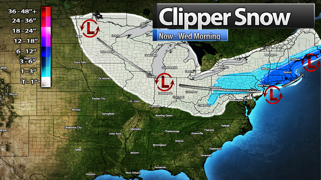
Good evening, A winter storm is around the corner for portions of the Midwest and Northeast. Here are the current winter weather hazards: 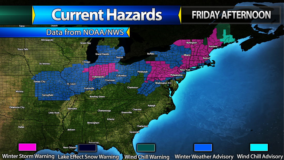
In connection to this, here is my final forecast for the snowfall accumulations with this storm. Please note that higher amounts are possible in the purple area. 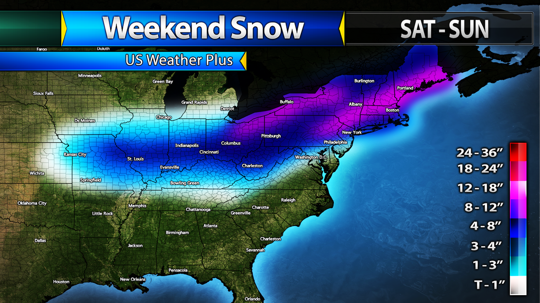
Stay safe and also don't miss the next post with my forecast for the next two weeks!
-Mark The GFS and Euro are both in agreement for a couple days now in some sort of system affecting the East US next weekend. Right now, ti is hard to say what kind of system it will be and when it will be, but I wouldn't be surprised if it turns out that it will be some snow/ice event in the Mid-Atlantic and Southeast, around next Sunday. Here is the GFS for next Monday morning. 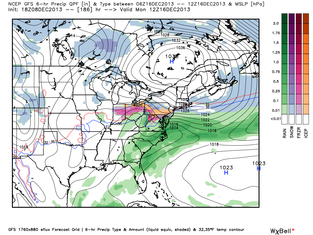
The GFS shows an ice storm in Pennsylvania and Ohio, and it is too far out to say now will it happen or not, although this image here does show blocking in Canada which means the pattern might be favorable for this storm. Below is the EURO at next Sunday afternoon. 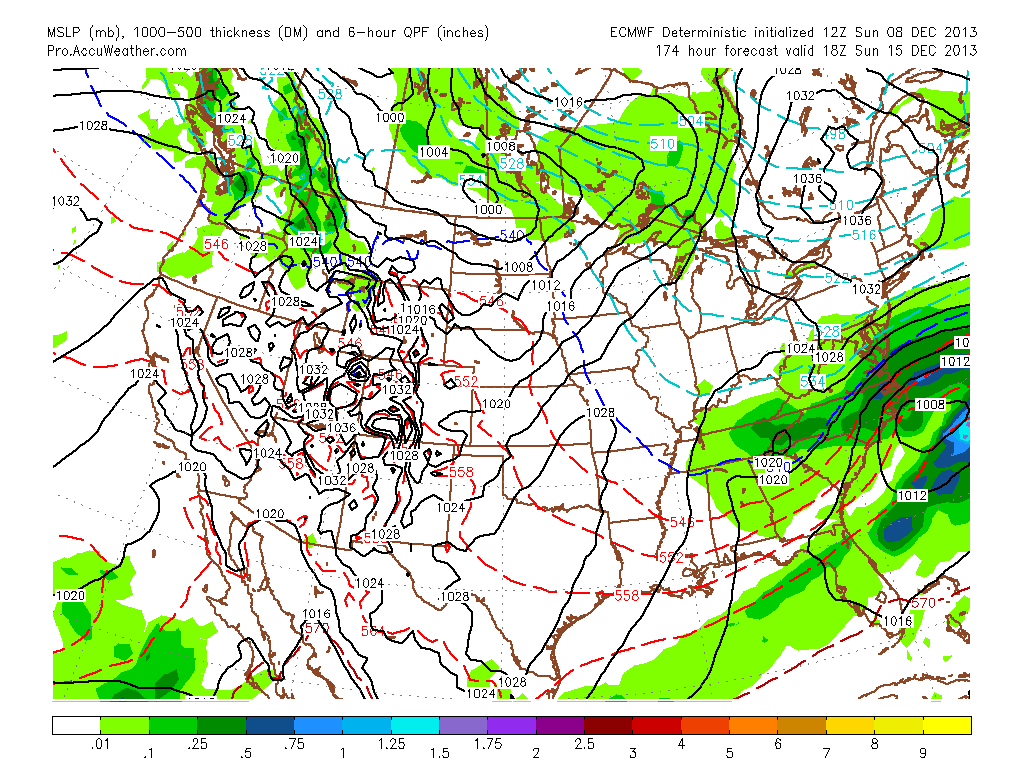
The EURO is a little different, bringing the system out a little earlier and also bringing its track more south. It also bring the snow more southward. It also agrees on blocking in Canada.
According to both models, this might be a possibility of more winter weather for the east, but too many factors make the forecast very hard, if not impossible, for what will happen in 8 days. Stay tuned for more updates as we get closer t this system, and keep an eye on the sky if you are in the Northeast tonight! Mark Good afternoon, A winter storm is impacting the Northeast today. Areas in New York, New Jersey, Pennsylvania, Maryland, and Virginia are getting hit by heavy snow, so please exercise caution while on the roads. Also, portions of Virginia are being in an ice storm, so please use extreme caution in Western Virginia and Eastern West Virginia. Round #2 of the winter weather is coming tonight, and we could be talking about more ice in North Carolina, Virginia, West Virginia, and Maryland. Expect major ice accumulations and widespread power outages along I-81 from Bristol to Hagerstown, as well as surrounding areas including the cities of Asheville, Boone, Roanoke, Blacksburg, Lynchburg, Hot Springs, Charlottesville, and Harrisonburg. In addition, we could still expect lots of snowfall with Round #2 tonight in the Mid-Atlantic and into New England. Below the post are my forecast maps. Also, stay tuned for a post on the next possible system and if it might produce any hazards for the US! Mark |


 RSS Feed